Navigators for pedestrians in Russian. Yandex.Maps is a faithful assistant for pedestrians and motorists
Yandex.Navigator is one of the most popular navigators for Android OS in Russia. The application boasts rich functionality, an interface completely in Russian and the absence of intrusive advertising. Also, the fact that it is absolutely free can be called an indisputable plus. Further in the article, you will learn how to use Yandex.Navigator on your smartphone.
After reading the material below, you will learn how to set up the navigator, get directions online and offline, and use its additional tools in unforeseen situations on the road.
Step 1: Installing the App
To download Yandex.Navigator on an Android smartphone, follow the link below, click on the button "Install" and wait for the app to finish downloading to your smartphone.

Step 2: Setting up
- In order for the navigator to be convenient to use, you need to customize it for yourself. Therefore, after installation, go to Yandex.Navigator by clicking on the application icon on the desktop of your smartphone.
- At the first launch, two requests for permission to access the application to geolocations and a microphone will pop up on the screen. For correct operation of Yandex.Navigator, it is recommended to give your consent - click "Allow" in both cases.
- Next, click on the button "Menu" in the bottom right corner of the screen and go to "Settings". First there will be a column of settings related to the card. Consider only those of them that really affect the use of the navigator.
- Go to the tab "Map View" and choose between the standard street and road map or satellite. Everyone sees maps differently, but schematic maps are easier to use.
- To use the navigator offline, go to the menu item and click on the search bar. Next, select the proposed maps of countries, regions, territories, cities and numerous provinces, or use the search by writing the name of the area you need.
- To change your location icon, go to the tab "Cursor" and choose one of the three options.
- Another important column of settings is "Sound".
- To select a voice assistant, go to the tab "Speaker" and choose the sound you are interested in. There will be standard male and female voices in foreign languages, and six positions are available in Russian.
- For complete convenience, the remaining three items should be left enabled. Voice activation will help you navigate your route without taking your eyes off the road. It is enough to say the destination address after the command "Listen, Yandex".


After you confirm the permissions, a map opens with an arrow icon showing your location.


To select the language you are interested in, in which the navigator will show you the route and other information about the road, go to the appropriate tab and click on one of the suggested languages. Then, to return to the settings, click on the arrow in the upper left corner.


This completes the basic settings for the convenience of using the navigator. There will be a few more items at the bottom of the list of parameters, but they are not so significant as to focus on them.
Step 3: Using the Navigator


After that, you just have to go according to the instructions of the announcer. But do not forget that this is a technique that can sometimes be wrong. Pay close attention to the road and traffic signs.
Yandex.Navigator can also show traffic congestion in order to avoid traffic jams. To activate this function, click on the traffic light icon in the upper right corner. After that, the roads of the city will become multi-colored, which indicates their congestion at the moment. Roads come in green, yellow, orange and red colors - the gradation goes from a free road to a long-term traffic jam.

For the convenience of the user, Yandex.Navigator developers have added the function of specifying comments to traffic events that are available to any driver or pedestrian who is not indifferent to incidents. If you want to add an event, click on the triangle icon with a plus inside.

At the top of the screen, a list of pointers will immediately open, which you can set on the map with any comment. Whether it's an accident, road repair, cameras or any other incident, select the desired sign, write a comment, hover over the desired location and click "Install".

A small pointer will then be visible on the map at that location. Click on it and you will see information from the user.

Recently, Yandex.Navigator has added a function to display parking lots. To activate it, click on the button in the form of an English letter in the lower left corner "P".

Now on the map you will see all the parking spaces available in the locality where you are. They will be highlighted with blue stripes.

At this step, the main work with the navigator ends. Additional options will be discussed next.
Step 4: Work offline
If you do not have the Internet at hand, but have a working smartphone with a GPS receiver, then Yandex.Navigator will help you get to the right place in this case too. But only on condition that maps of your area have already been loaded on your smartphone or a route you have previously built has been saved.
With the available maps, the route construction algorithm will be similar to the online mode. And in order to save the required route in advance, press the button "My Places".

The next step is to enter your home and work address, and in the line "Favorites" add those addresses where you often go.

Now, in order to use the application offline with preloaded maps, say a voice command "Listen, Yandex" and specify or select manually the place where you want to create a route.
Step 5: Working with the tools
The menu has a group of tabs called "Tools", and several of them may be useful to you. They work only with an active Internet connection on your Android smartphone.


This concludes our instruction on working with the application. There are many interesting and long-existing solutions of this kind, but Yandex.Navigator boldly keeps among them in good standing with many users. So feel free to install it on your device and enjoy it.
With the onset of the warm season, more and more people prefer to spend time outdoors. Hiking and cycling allow you to relieve stress at the end of the day, improve your health and get fresh impressions. Moreover, with the help of "" you can now lay new walking routes at least every day.
In the web version of the maps, all you need to do is click on the "Routes" button, and then set the start and end points. A smart algorithm will build the shortest route between these points using roads with sidewalks, footpaths, paths, stairs, arches, walkways between buildings, and so on.

Please note that it is possible to collect a route from several points. So if you want to visit several places at the time, then this is not a problem. On the map you can also see the distance to each point and the total time of the route. The maximum route length is 50 kilometers. However, in most cases this is sufficient.
This feature looks just as nice in the mobile app. Here, Yandex.Maps will not only build a walking route for you, but also guide you from beginning to end in navigation mode.


Please note that navigating footpaths and paths is quite a challenge due to the fact that in any area there are hundreds of times more of them than roads. However, the developers of "Yandex.Maps" managed to solve this problem with honor. During my little testing, I laid out routes to places that I knew well, and the application almost always found the best option.
This result is achieved due to the fact that not only developers, but also ordinary users took part in filling the Yandex.Maps cartographic database. You, too, can contribute, because who else but you knows so well all the yards, paths in parks and paths in your area. For this, there is a "People's map", the data of which, after approval by the moderators, are used when building walking routes. This feature is currently active in Russia, Belarus, Kazakhstan, and Ukraine.
In order to always easily find the right way in any city and in any place, most people use GPS navigators, but technology does not stand still: now you can have a convenient and fast navigator right in your smartphone. The Yandex service provides its users with a free Yandex.Navigator application, which is designed to take you anywhere in the city in the shortest possible way. The application is equipped with speakers, comments from other users, up-to-date data on traffic on the roads, traffic jams and repairs. Download this program for yourself and learn how to use it with the help of this article.
Downloading Yandex.Navigator and specifying the path
- You can easily download the Navigator from Yandex in the Play Market or the AppStore. Click "Install" after finding the app and wait a few seconds.
- Now sign in to the app. To find yourself on the map, you need to turn on location data on your phone. Open the tray of the device by swiping down on the screen with your finger, click on the “Geodata” icon and wait until it changes color.

- Now your current location will be instantly determined.
- Pay attention to the bottom panel in the program: all the necessary tools for working with the navigator are located here. The most important thing is finding a route. Try to pave your first path right now. Automatically your location is determined as point "A". Find your destination on the map and click on it.

- If you do not know where the place you are looking for is located, then just click on the “Search” icon. In this menu, you can either enter the address or name of the place, or search for it in the categories.


- As soon as the system determines the available list of places, click on the one you need.

- Now you see the possible options for point "B" on the map.


- Click on one of them, and then select the "Let's go!" field.


- That's all. The path is automatically set. If you have several route options, the time and kilometers for each of them will be indicated on top. The system will also notify you of traffic jams and repairs.


- Follow your path on the top bar. These tools will be very useful to you to quickly navigate the road.

How to add favorite places to Yandex.Navigator
To navigate in just a couple of seconds, you can add the most frequently visited places to a special list.
- Open "My Places".


- Here you will see handy bookmarks like "Home" and "Work". Add addresses or points on the map to them.
- In the “Recent” section, you have access to all the addresses that you have recently visited.


How to log in to Yandex.Navigator
Users authorized in the system can synchronize all settings on devices. This is very handy if you have multiple phones or if you suddenly get lost with a friend who has such an application.
- Press “Menu” again and then the “Login” button.


- The convenience of the system is that you can use not only a Yandex account for authorization, but also any social network.
- As soon as you sign in and give the application access, authorization is complete.


How to set up Yandex.Navigator
The application has a user-friendly interface and many flexible settings. By selecting the “Settings” item in the menu, the following options become available:
- Map view from satellite or schematic.
- North location.


There are some minor points of interest:
- Announcer's voice. There's even Optimus Prime here.
- Setting up an appeal to Yandex by the command “Listen, Yandex”.
Customize the application to suit your needs and tastes.


Yandex.Navigator tools
The menu has a separate item "Tools". You should know why you need it.
Here you can mark your fines so that you always remember them, store your trip history, quickly find nearby car towing companies, commissioners. Don't forget to add penalties so that the app reminds you of them.

How to add a mark on the map in Yandex.Navigator
If you witnessed an accident or saw repair work on the road, you can notify other drivers about it.
- Click on the location on the map where the blockage occurred. Select the triangular road sign icon on the left.


- Now note what exactly happened on the road and select a lane if necessary. You can also just leave a comment on this place by clicking on the gray icon.
- So simply you can connect with other drivers right in your navigator.


Today, there are special devices that will not allow a person to get lost while traveling. A navigator for a pedestrian, a mushroom picker, a tourist will become a reliable assistant on a hike. How to choose the right device, what parameters to consider, which manufacturer to give preference to? Tourist navigators do an excellent job with their direct duties: they help to navigate the terrain, indicate the real location of a person, the desired direction of movement. Navigators for the forest are a great gift for lovers of an active lifestyle.
How to choose a portable navigator
Mushroom pickers, fishermen, hikers, for greater confidence, will probably need satellite navigation. Modern devices guarantee trouble-free operation even in bad weather, in mountainous areas or in dense forests. A navigator for a pedestrian, a mushroom picker, a tourist will help you choose the knowledge of the basic requirements that the device must meet.
- The number of navigator points affects the duration of the track, that is, the path traveled by a person. Naturally, the more of them, the longer the route will be remembered by the device. Even if you do not plan to use this feature, it is useful to have it in your navigator. Setting marks will make it easier to navigate in a completely unfamiliar area, mark the places where you stopped or passed. Many generally prefer to save successful routes on a personal computer.
- Built-in memory primarily affects the number of maps that can be loaded. The amount of memory affects the usability of the device, that is, the ability to scale up. The question arises which tourist navigator is better to buy - the answer is unequivocal - give preference to devices with a large amount of internal memory, or purchase an additional memory card.
- Battery life is a very important parameter, so you can not ignore it. It is hard to imagine a person going for mushrooms for only thirty minutes, usually such trips drag on for a long time. Accordingly, the navigator for mushroom pickers should work for at least several hours. Sometimes there are various unforeseen circumstances on a hike, so draining the battery in an unfamiliar area can be very untimely and problematic. It is better to give preference to devices with the lowest possible power consumption and large battery capacity.
- The convenience, speed of scrolling the map or zooming in depends on the processor. Many people correctly choose navigators with a higher clock frequency, because such devices load and work faster.
- Dimensions. Which tourist navigator to choose, what should be the dimensions of this device? Every traveler knows: extra grams cause inconvenience on the road. If you do not climb mountains, do not overcome tens of kilometers a day, you can ignore this parameter. Otherwise, experts recommend choosing small navigators that easily fit in the palm of your hand.
- Strength properties are equally important. If you do not want to navigate by the stars, choose a navigator with a case made of reliable and impact-resistant material. Poor quality plastic can break at the wrong time, leaving you in a rather difficult position. In addition, there is always a chance of getting caught in the rain while hiking. Water resistance is an important parameter of a tourist navigator, so you should not buy a device without moisture protection.
- The screen of your navigator should not be very small, otherwise, instead of the required image, you will see only incomprehensible reflections.
Top Models
It is clear how to choose a tourist navigator, then we will consider popular models for ordinary walks or tourism. Today, navigators can easily replace ordinary paper maps and help you get out of even the most impenetrable thicket.
The Etreks series was appreciated by mushroom pickers, hunters, ordinary tourists. All devices are very clear, easy to use, controlled by a special joystick located above the screen, as well as buttons located on the sides of the device.
Garmin GPSMAP 64ST is the best travel navigator. Hiking enthusiasts liked this device for its survivability and functionality. In addition to the gadget itself, in the box you will find a cable for connecting to a PC, a carabiner for ease of use, a warranty card and an instruction manual. Batteries and accumulators are not included. The Navigator boasts a quality build. The case of the device, made of durable plastic, looks monolithic and weighty, is characterized by moisture resistance and impact resistance. Management is carried out using convenient buttons located on the front panel. In addition, the gadget has a massive antenna, a micro-USB port and a connector for an additional antenna. By the way, the antenna recognizes signals from a large number of GPS satellites, as well as the Russian analogue of GLONAS.
The resolution of the 2.6-inch color display is small (160 by 240 pixels), which means that there is graininess, which, by the way, practically does not interfere with the work with the navigator. Thanks to a convenient backlight, you can work with the gadget in the dark. The software works stably, the built-in memory (8 GB) is enough to keep in the device not only a road map, but also other interesting places, it is possible to increase the volume by connecting an external memory. Navigator 16 hours does not require recharging, easily synchronizes with a smartphone and other devices.

The Garmin eTrex 10 is the cheapest navigator and has a simple black and white 2.2-inch LCD display. Since this model does not have touch support, the control is carried out using a joystick. The image on the screen is perceived well, regardless of the illumination of the area. Dimensions allow you to carry the navigator in your pocket, and the recesses and bulges on the case make it much easier to use. Accidental contact with water will not affect the quality of work. It is also worth noting the exceptional strength of the product, its resistance to shock, ubiquitous dust and dirt.
Such, at first glance, quite an ordinary navigator can boast of a fairly long work (at least 25-30 hours). Working with GPS and GLONAS opens up the possibility to travel without fear of getting lost. By the way, the Russian system usually finds a location faster than the world one. The disadvantages of the navigator are minor: low screen resolution, lack of blocking.

The review will continue with the improved Garmin eTrex 20, which replaced the budget eTrex 10 on the market. The gadget is compact in size, the case has rubber inserts, the necessary fastening devices, and rather large buttons that facilitate operation. This model interacts with GPS and GLONAS, is produced with an already built-in package of maps "Roads of Russia", which is an additional plus. Information is displayed on a color screen, thanks to the use of 65 thousand colors, the picture is natural. The presence of built-in memory (1.7 GB), part of which is already filled with useful information, will significantly increase the efficiency of the device. Etreks is the best navigator for the forest in the middle price category. Such a device will be able to capture and fix the signal even in the most difficult conditions.

The rating will continue Garmin eTrex 30x. This model represents the next generation of navigators, it costs a little more than the previous device. Whether such a price is justified, we will consider by comparing the tourist navigators of this manufacturer. The diagonal of the color display is the same - equal to 2.2 inches. Thanks to the special IPX7 system, the device is completely waterproof. Experiments that were carried out with the navigator confirmed this statement. Even after a twenty-minute stay in the water, the device continued to work. In addition, falling on a hard surface also did not disable it.
The navigator is equipped with an altimeter that measures altitude, the lunar calendar available in the device will give you information about sunrise or sunset. Naturally, the device supports all cards, it is possible to transfer information to other similar devices. Sensitivity to satellites is excellent, the device quickly determines the location.
Maps are easy to install. Charging is enough for 25 hours of work. By inserting lithium batteries, you will further increase the operating time. The uniqueness of this model in the possibility of use by motorists. Even the longest journey with such a device will become pleasant and easy.

The Garmin Dakota 20 is a compact navigation device. A small gadget feels equally good in male and female hands. The sensor occupies almost the entire front of the device, there is only one button for turning on / off, changing the backlight. Naturally, there is a strap attachment. The battery is isolated from water and dust with a special cover and a thin rubber band located around the perimeter. Unlike eTrex, which last up to 30 hours, Dakota will last no more than 12. Another drawback of this model is the weak backlight of the screen, the inability to use it with a laptop as a signal reception.

A well-known Chinese company is known for the release of navigation equipment. The line of navigators is represented by four devices: nava 200, nava 300, nava 400 and nava 600. These devices are designed not only to obtain the necessary cartographic data, but also to carry out various measurements. The scope of navigators is extensive: from tourism to use in agriculture and forestry. Such devices have a good price, decent functionality.
The nava 200 is a compact device with a sensitive GPS receiver and a loaded world map. The case reliably protects the device from water, dust, shocks. Thanks to the rubber pads, the navigator is easy to hold in your hands, which is especially valuable in rainy weather. The small size allows you to carry the device in your pocket or on your belt. By the way, the set includes a special lanyard for carrying. The interface is clear and simple, the control is carried out with a minimum of pressing buttons. Routing can be done automatically. The device is easily synchronized with other devices. Charging the navigator is enough for 15 hours.

We will finish the rating with an inexpensive tourist nava 600 navigator. This full-featured model copes with all the tasks that high-quality navigators are designed to perform. The device is equipped with a color display that guarantees excellent picture quality. This device can be used regardless of the time of day, the resolution is 240x320, stores up to 50 tracks and 5 thousand points in memory. The navigator is equipped with an electronic compass, calculator, thermometer and altimeter, has a hunting and fishing calendar, will give information about the moon and the sun. The device is not afraid of falls, high humidity, dust and dirt. Light weight and dimensions allow you to carry the navigator in your pocket, on your belt or around your neck.

Probably, there is no such tourist who would not be afraid to get lost. Paper maps and compasses are gradually becoming a thing of the past, giving way to more advanced gadgets. Modern nava or eTrex will solve any problem on the ground: from determining the location to calculating the direction of movement. These devices work for a long time, are equipped with many additional functions.
While driving along the route, the Navigator screen shows:
Route segment
To view the entire route, press the button. To return to the current segment, press the button.
Route parameters:
- distance to destination and estimated time of arrival;
- traffic jams on the route;
- upcoming maneuver and distance to it;
- speed limit on the route.
Note. If the speed limit shown by the Navigator is incorrect, tap the limit icon and select the correct value.
Attention. If the setting is enabled North is always up, lanes are not shown.
The lanes are displayed in several major cities, at difficult turns and intersections. Also, lanes are shown if you need to stick to certain lanes while driving.
If the lane is intended for a specific type of transport, such as buses or bicycles, then a special sign will appear next to it.
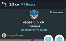
To make Navigator warn you about cameras, speeding, and traffic conditions, set up audio alerts for traffic events.
Working in the background
The navigator can work in the background, i.e. lead along the route and give hints when the application is minimized. Background support works both with the built route and without it.